Part of the Continuing Series The Lake George Pinhole Mysteries
AUTHOR’S NOTE : The Intentional Inadequacy of the Spillway GREATLY Profits the State and Hydro Power Company. These Penstocks and Dams are used to HARNESS the HP of the Lake. Succinctly stated IT’s ALL Done on PURPOSE. JBW
Accession Number : ADA090941
Title : National Dam Safety Program. Lake George Outlet Dam (Inventory Number NY 230), Lake Champlain River Basin, Essex County, New York. Phase I Inspection Report,
Corporate Author : NEW YORK STATE DEPT OF ENVIRONMENTAL CONSERVATION ALBANY
Personal Author(s) : Stetson,John B
PDF Url : ADA090941
Report Date : 28 Aug 1980
Pagination or Media Count : 156
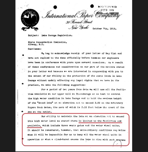
Abstract : The examination of documents and visual inspection of the dam and appurtenant structures did not reveal conditions which constitute an immediate hazard to human life or property. The dam, however, has a number of problem areas which should be investigated further. The structural stability analysis indicates unsatisfactory stability for the dam when subjected to forces which could occur during winter operations (including ice loading), the Probable Maximum Flood (PMF), and 1/2 PMF events. A structural stability investigation of the dam should be started within 6 months to determine the effect of the dam’s steel bar anchor system and the uplift forces acting on the base of the dam. Remedial measures should be completed within 2 years to increase the structural stability of the facility to meet the Corps of Engineers screening criteria. The hydrologic/hydraulic analysis establishes the spillway capacity as 46% of the Probable Maximum Flood (PMF) with the sluice gates open and 30% of the PMF if the gates remain closed throughout the storm. The dam will be overtopped by 2.72 feet by the PMF with the gates closed or 2.55 feet with the gates opened. However, the spillway is capable of passing the 1/2 PMF under either of these two conditions without the dam being overtopped. Therefore, the spillway is assessed as inadequate according to the Corps of Engineers screening criteria.
Descriptors : *DAMS, CONTROL, STABILITY, NEW YORK, HYDROLOGY, DEFICIENCIES, SAFETY, LEVEL(QUANTITY), VISUAL INSPECTION, FLOODING, LAKES, RESERVOIRS
Subject Categories : Hydrology, Limnology and Potamology
Civil Engineering
Distribution Statement : APPROVED FOR PUBLIC RELEASE
Two Headed Lake Trout Caught in Lake Champlain
THEY KNEW FULL WELL THE WASTE GATES WERE INADEQUATE
BREAKING VERMONT TAXPAYERS ERUPT ….. BILLIONS SOUGHT TO CLEAN LAKE CHAMPLAIN FROM NEW YORK’S MEGA MESS
UPDATE FROM THE PO’d Taxpayers of Vermont. Read the Comments regarding WHO PAYS
https://vtdigger.org/2017/02/24/lawmakers-look-fees-taxes-fund-lake-champlain-cleanup/
The FUND For Lake George and the Lake George Park Association ….. FLUSHS to Lake Champlain ….. Can You hear those GIANT Flushing Sounds ?

Target New York THE Vast Poisoning of New York’s Watersheds
The Pictures simply do NOT Lie https://www.google.com/search?…
YOUTUBE.COM

This is what Flushing Lake George to Lake Champlain does

Life in the Shallows of Lake Champlain
Lake Champlain is up to 10 miles wide and 120 miles long. Beneath the waves it ranges in depth all the way down to an…


UPDATE LOOKY HERE International Paper & Power GIFTING Big Big Property and Bucks to NEW YORK STATE …. Interesting 1974 …. Just After the Repeated DESTRUCTION of the Witham Family Marina ….. HOW NICE
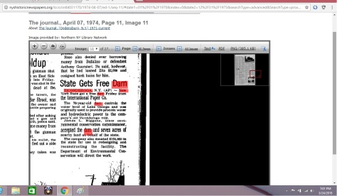
7 Acres $150,000.00 and a FREE DAM WOW

Hudson River, Glens Falls Feeder Canal, Champlain Canal and the Poop Chute River TICONDEROGA
VERY INTERESTING EXPOSURE OF THE PULP & PAPER MAFIAS and Government SEWAGE DUMPING
“When once a republic is corrupted, there is no possibility of remedying any of the growing evils but by removing the corruption and restoring its lost principles; every other correction is either useless or a new evil.” — Thomas Jefferson –
The PINHOLE EXPOSED ……. Imagine that A PINHOLE in a Bath Tub ……. ASK The Lake George Association and the Lake George Park Commission oh AND DEC ……. Pinhole It’s a FACT
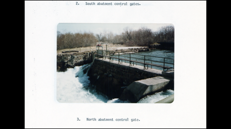
Notice the Two Small Drain Gates for the 242 Sq Mile Lake Basin
LAKE GEORGE PARK COMMISSION Lake Level
http://www.lgpc.state.ny.us/lakelevel.html ( THE PINHOLE PURPOSELY ENGINEERED DESIGNED AND CONSTRUCTED TO WRING PROFITS FROM THE LAKE )
The capacity has been likened to draining a bathtub through a pinhole. When water entering the lake exceeds the maximum rate that can be discharged, the lake rises. Each winter the lake is drawn down in anticipation of the spring snow melt. Snow surveys help to estimate the amount of water that is resident in the basin’s …
Merely 46% Capable AFTER UPGRADING in 1975 …. Less Than 1/2 The Release Capacity required 54% Wholly Inadequate AFTER the Upgrade
YUP New York State Gets a FREE DAM HAHAHAHAHAHA Free Dam MY ASS The FREE DAMThat’s Cost … The Release Capacity at Lake George NY at Dam # 230 AKA …
Lots and Lots and Lots of Pictures DO NOT LIE
AUTHOR’S NOTE : The Intentional Inadequacy of the Spillway GREATLY Profits the State and Hydro Power Company. These Penstocks and Dams are used to HARNESS the HP of the Lake. Succinctly stated IT’s ALL Done on PURPOSE. JBW
See Lake George, THE FACTS Not the Fiction
Ponding Back the Horsepower and Creating all the Mill Wastes and Sewage

The Emerald Green Waters of The Queen of America’s LEACHATE POISONED LAKES

The Continuing Saga of the Great Toilet Lakes and Toilet Rivers FLUSHED across AMERICA
|
|
|
||
|
||||
According to the US ARMY CORP, Lake George Park Commission (AKA The State of New York) and the Stetson Engineering Company ( NYS engineering Inspectors ) as well as The State Conservation Commissioner and NYS Attorney General
Dear New York State The TRUTH IS LOOSE ….

The Great TOILET LAKES Flushing Crapper, Flushing the Toilet Rivers too
National Dam Safety Program. Lake George Outlet Dam (Inventory …
The dam will be overtopped by 2.72 feet by the PMF with the gates closed or 2.55 … Therefore, the spillway is assessed as inadequate according to the Corps of Engineers screening criteria.*DAMS. … Lake George Outlet Dam (Inventory Number NY 230), Lake Champlain River Basin, … Personal Author(s) : Stetson,John B.
DAM “A” on Lake George at Weedville is 54% incapable of controlling Lake Levels. There has been a FORTUNE MADE from Winter Time ICE DAMAGE caused by Lowing the Pool in the Winter. NOT just the Dock Repair Industry on the Lake BUT the Mills and Electric Companies have pocked a FORTUNE. Flushing Lake of Pollution and Sewage has as well made certain BANKERS and Land Speculators, filthy rich.
Civil engineers when designing a dam must establish the capacity of the dam and the rate at which water can be passed through the dam by means of flood gates. Flood gates are an expensive component of a dam’s construction so engineers must consider a trade-off between the cost of the dam and the security it will provide.
The dam design determines the probability that a storm will cause the dam to overflow and possibly destroy the structure. If this probability is 0.01 then the dam is said to be able to handle any thing up to a 100 year flood; i.e., a flood that occurs on average once in a hundred years. This terminology is misleading because it implies that severe storm occurrences are independent random events whereas this is not the case. The random events may be the weather conditions. The weather conditions that produces one severe storm may persist and produce another severe storm not long afterwards. Hurricanes and other tropical cyclones tend to be spawned in sets so one severe hurricane may be followed by others in a short period of time.
The policy of operation for the dam is a factor in determining the probability of catastrophic failure. If a dam is held empty it has the greatest capacity for control of severe floods. But such a policy would destroy the usefulness of the dam for storing water for providing Plant or Mill water. And if the dam reservoir is being kept empty then the small flood are not being controlled. On the other hand if the dam does not retain some unutilized capacity it will be useless for controlling flood dangers. The dam authorities must decide the proper excess capacity to maintain based on the trade-off they see between the value of stored water versus the value of flood control. Note that in the matter of using dams for flood control it is a question of reducing the cost of small floods at the expense of increasing the damage from the floods which bring about the catastrophic failure of the dam because the water stored behind the dam will be added virtually instantly to the flood. The failure of one dam will quite likely lead to the failure of other dams down stream. The effect will be cumulative.
Some simple algebra shows the nature of the problem. Let the storage capacity of a dam be C and let G be the rate at which water can be passed through the dam based upon the number and size of the flood gates built into the dam. Let the unutilized capacity of the dam be E and the normal stored water be A. Thus A+E=C. A storm may be characterized by the magnitude of the flow at the dam site F and the duration of the flow D.
The rate at which the dam fills up is given (F-G). The time it takes the flood to fill up the unutilized capacity is E/(F-G). If this is greater than the duration of the storm then the flood is contained but if E/(F-G)<D then there is a catastrophic failure. The flood flow down stream jumps suddenly from G to (F + C/T) where T is the length of time it takes for the failed dam to empty. The dam authorities have to consider the effect of design and operating policy choices on an objective function of the form <!–
f(A) – p(E/(F-G)<D)g(F+C/T)
–>
where f (A) is the value of having stored water of amount A, is the probability of a dam failure and is the downstream cost of the failure. The probability of a dam failure is a matter of the probability of the combination of F and D and .
DAM “A ” and the Electrical Penstock on Lake George are WHOLLY RESPONSIBLE for MEGA Damages throughout the Lake Basin and the State of New York and Lake George Municipalities CAN NO LONGER CONCEAL THESE FACTS. JW
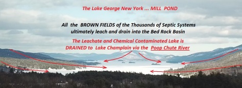
EVERY TIME LAKE GEORGE’s LEACHATE POLLUTED WATERS ARE FLUSHED TO LAKE CHAMPLAIN …… EVERY TIME

There are THOUSANDS of Lake Side Leach Fields all over the Lake George Basin. The Bedrock causes all that Sewage and Chemicals to Leach into the Lake ….. Go Figure Right
The ANNUAL PINHOLE FLUSHING OF LAKE GEORGE
New York’s Toilet Lakes and Toilet Rivers
THE DILUTION/FLUSHING TECHNIQUE IN LAKE RESTORATION …
Dilution/flushing has been documented as an effective restoration technique for Moses and Green Lakes in Washington State. The dilution … DILUTION/FLUSHING …
Flush Flush Flush FLUSHING Lake George and Poisoning Lake Champlain …. An Expose’ https://vimeo.com/207522264
WINTER TIME DRAW DOWN …… JUST THE FACTS
Separating the FACTS from the Sophistries and Sewage ….. The Real History of Lake George THE MILL POND ……

Protecting Andia’Ta’Roc’Te from the WORST of Invasive Species “MAN” to honor all GLENS FALLS INDIANS and LAKE GEORGE WARRIORS …….. Son of Swamp Fox

IMAGINE THAT a 2000 Year Old Indian Campgrounds SUBMERGED in 8 or 10 feet of water WEST of the Point ….. IN THE LAKE ….. The ARTIFICIAL Flooding of Andia’Ta’Roc’Te the MILL POND …….
The Upper Privilege DAM ” A ” Keeps Lake George 8 + Feet Higher than Natural (see page 34 )

The Upper Privilege DAM ” A ” Keeps Lake George 8 + Feet Higher than Natural (see page 34 )

Flushing the Sewage and Mill Wastes and Cesspool known as Lake George is REALITY

There are many thousands of Lake George Septic Systems
The US ARMY CORP Knows all about FLUSHING
eileen.l.williamson@usace.army.mil
Omaha, NE — The annual sediment flushing exercise will be completed at Cherry Creek Reservoir, near Aurora, Colorado on Wednesday, June 1, 2016.
Katie Seefus, water manager in the U.S. Army Corps of Engineers’ Omaha District office, says …. “When the gates are opened, the high velocity of the water leaving the reservoir scours the area immediately upstream of the gates and transports sediment with the flow,” said Seefus. The sediment flush is required to allow proper operation of the outlet gates. ( Just Like Lake George and the Poop Chute River )


HIGH RISK DAM and Wholly Inadequate rated a mere 46% able to SAFELY Handle a Flood


Dear New York DEC, Lake George Park Commission, Adirondack Park Agency , Governor Cuomo, Basil Seggos, Eric Schneiderman,
The Glens Falls Warren County MAFIA control over Lake George Explained ……. Generational OLD MONEY and lots of Politicians, Judges and LEOs with CONFLICTS OF INTERESTS. The Banksters of Glens Falls and Their INVESTOR CLASS Revealed


Follow the Racketeering Conspiracy Here https://theadirondacksconspiracy.wordpress.com/draw-down-lake-george-the-pin-hole-project/

Understanding The Giant FLUSHINGS of the LEACHATE LADEN QUEEN of America’s Leach fields …… Flushing the Brownfields of Lake George ….. Pre 1980 Records Requested from US ARMY
SEE ALSO THE DEC JOHN STETSON ENGINEERING REPORT
REPORTS OF THE NEW YORK STATE ENGINEER
PROOF That Lake George is ARTIFICIALLY FLOODED
SEE Lake George Outlet DAM “A”
Submerged Native Encampment West of Assembly Point
Flooded 5000 Acres of Land WOW 5000 Acres

Queensbury RATHER First Nations Land
NOTICE THE NW Corner Tract 13
And Look at the Road Across Dunhams Bay

Map Left 1800s Map Right 1700s
NOTICE ALL THE ODDITIES
The Burnt Ridge Artifacts
EXCEPT
The Burnt Hill ( Ridge ) phase is a recently discovered regional late Middle Woodland manifestation on Lake George, New York. On the basis of comparisons with related groups in central New York and the Hudson Valley, a temporal placement of about A.D. 800 is suggested. Salient ceramic traits include rocker-dentate, dentate, corded-stick and pseudo-scallop shell-like stamping on small to medium-sized vessels with straight or slightly flaring rims, flat, thickened or rounded lips, and elongate bodies with sub-conoidal bases. Other pottery features include vertically corded, punctate, incised, or complex decoration, appliqué collars, and scalloped or incipiently castellated rims. Broad triangular Levanna type points dominate the weapon inventory, but Jack’s Reef Pentagonal and Jack’s Reef Corner-notched types are minority forms. Possibly associated are thin side-notched points and Steubenville Stemmed points. Meager refuse food remains, the total stone tool assemblage, and local ecological factors indicate an economy based on hunting, fishing, mussel-collecting, and nut-gathering. Burnt Hill stations were probably occupied in warm months of the year by small bands of people consisting, perhaps, of a few extended families. These groups may have lived in small, temporary structures of poles and bark. As recorded for historic tribes, the bands may have split into family units during winter hunting rounds.
SEE Submerged Site IN THE WATER Assembly Point SEE APPENDIX X at Pg 302-317 SITE IS IN THE WATER
[PDF]Lake George Wild Forest Draft Unit Management Plan – PDF http://www.dec.ny.gov/docs/lands_forests_pdf/lgwfdf.pdWildlife Inventory . …… of the unit serve as important habitats for a number of wildlife species listed as.
2,000 Year Old Encampment Site Submerged off Assembly Point

Fitchburg Sentinel from Fitchburg, Massachusetts · Page 38
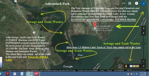
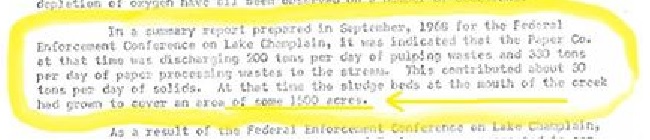
Dec 10, 1970 – Fitchburg Sentinel (Fitchburg, Massachusetts), Thursday, December 10, 1970, Page 38. … Lake Champlain, which forms Vermont’s scenic western border, … A million and a half cubic vards of paper mill sludge, nearly half the …

Please Share Your Records Per FOIL on these issues 1/13/17 JBW
Up and Down Up and Down Up and Down The Lake George Ice Sheet is Manipulated Every Winter to FLUSH The Lake George Toilets
FLUSHING THE MILL POND …… The Historical Record
Flushing the Commode FLUSH FLUSH FLUSH FLUSHING
THE CESSPOOL Lake George
The Glens Falls Feeder Canal, Champlain Canal, Hudson River and Lake George ALL FLUSH Pollution into Lake Champlain …….
Toxic Sludge and Sediments in Both Lake George and Champlain
The Boat Engines are a mere 60% Efficient at best

BEWARE The NEW YORK STATE CONservation Racketeers
The TOXIC Sludge, Sediments and Mud of the MILL PONDS

LAKE GEORGE, N.Y., Aug. 18. –The Lake George Association meeting today at the Lake George Club requested the State Conservation Department to take steps to obtain legal relief in the matter of Lake George water levels.
See Draw Down Show Down ……. The BATTLE For Lake George
“A” Gargantuan Flushing Machine DAM “A” LaChute River
SEE The Poisoning of Lake Champlain BY New York’s Industries
US ARMY CORP ENGINEERS rates Lake George’s Release Dam as INADEQUATE …. See Report for Dam 230 ( Ticonderoga )

Submerged Native Encampment Fire Assembly Point
Queensbury RATHER First Nations Land
The Burnt Ridge Artifacts
EXCEPT
The Burnt Hill ( Ridge ) phase is a recently discovered regional late Middle Woodland manifestation on Lake George, New York. On the basis of comparisons with related groups in central New York and the Hudson Valley, a temporal placement of about A.D. 800 is suggested. Salient ceramic traits include rocker-dentate, dentate, corded-stick and pseudo-scallop shell-like stamping on small to medium-sized vessels with straight or slightly flaring rims, flat, thickened or rounded lips, and elongate bodies with sub-conoidal bases. Other pottery features include vertically corded, punctate, incised, or complex decoration, appliqué collars, and scalloped or incipiently castellated rims. Broad triangular Levanna type points dominate the weapon inventory, but Jack’s Reef Pentagonal and Jack’s Reef Corner-notched types are minority forms. Possibly associated are thin side-notched points and Steubenville Stemmed points. Meager refuse food remains, the total stone tool assemblage, and local ecological factors indicate an economy based on hunting, fishing, mussel-collecting, and nut-gathering. Burnt Hill stations were probably occupied in warm months of the year by small bands of people consisting, perhaps, of a few extended families. These groups may have lived in small, temporary structures of poles and bark. As recorded for historic tribes, the bands may have split into family units during winter hunting rounds.

Flush toilet – Wikipedia 
A flush toilet is a toilet that disposes of human excreta, by using water to flush it through a drainpipe to another location for disposal, thus maintaining a separation between humans and their excreta. Flush toilets can be designed for sitting or for squatting, in the case of squat toilets. The opposite of a flush toilet is a dry toilet which uses no water for flushing.
DEAR NYS Jan 27, 2017
|
3:44 PM (1 hour ago) | |||
|
||||
Ticonderoga townclerk@townofticonderoga.org Lake George Village lgvclerk@nycap.rr.com Lake George Park Commission info@lgpc.state.ny.us Town of Lake George supervisor@lakegeorgetown.org , mmuratori@lakegeorgetown.org nstannard@lakegeorgetown.org , vcrocitto@lakegeorgetown.org NYS DEC central.dispatch@dec.ny.gov, info.R5@dec.ny.gov, pressoffice@dec.ny.gov
Lake George Park Commission ( info@lgpc.state.ny.us )
On Fri, Jan 27, 2017 at 3:28 PM, SwampFox <notjuris@gmail.com> wrote:
The Lake George Park Commission Has been involved in Lake Drawdowns for many decades. Annual Winter Drawdown on account of the Inadequate Spillway that the Army Corp of Engineers reports several times. LGPC calls the Inadequate Dam Release Ability ” A Pin Hole in the Bath Tub “
The LGPC with the Lake George Association has for many years with the NYS Park Commission, DEC, as well as the NYS Attorney General’s Office and Warren County, litigated, executed, implemented Lake George Water Level Drawdowns lowering and raising Lake George huge numbers of times. The Director of LGPC , Warren County, New York State have many many many times issued Repair and Replacement Permits and reviewed plans and approvals and inspections because of Ice Damage and Lake Level Ups and Downs associated with the Lake Levels going Up and Down.
Your Commissioners, Your Office, with Lake George Association, NYS DEC, Warren County and numerous other Groups have been in Court, Given Testimony, Witnessed and implemented the Lake Levels Changes for Decades.
I have been requesting these records for a significant amount of time. Lake George Park Commission is an arm of the State of New York , Warren County as well as the Town of Lake George. LGPC has an obligation to keep the above records. Films, Recordings, Photos, Video , Notes, Letters, Court Records etc.This is the CATAGORY of records I have clearly identified before. Please produce them.
Thank You
Judson Witham
Anita and Clifford Witham Family Estate
Should You have any questions about DRAWDOWNS AKA Flushing Lake George during Winter Ice and Snow Cover The Following Individuals Should Be Asked for Guidance.
Lake George Park Commission 75 Fort George Road, PO Box 749 Lake George, New York 12845 Phone: 518-668-9347 Facsimile: 518-668-5001 General Email: info@lgpc.state.ny.us
Board of Commissioners
Bruce E. Young, Chairman William Mason John C. McDonald Jr. Catherine LaBombard Joe Stanek David G. Floyd James T. Kneeshaw Dean Cook Kenneth W. Parker Basil Seggos, Commissioner, DEC, Ex-Officio* *Marc Migliore, Commissioner Representative
Counsel
Eileen Haynes
Commission Staff
David Wick – Executive Director F. Joe Johns, Director of Law Enforcement Keith Fish, Director of Operations Roger Smith, Conservation Operations Supervisor Molly Gallagher, Environmental Analyst 2 Joe Thouin, Environmental Analyst 1 Justin Luyk, Park Ranger
ALSO PLEASE SE
-
Draw Down Lake George – Expose The Pin Hole Project | The …
https://theadirondacksconspiracy.wordpress.com/draw-down–lake…
- … North Country “A” Dam ” A ” the Money Machine Lake George New York 8 Feet Higher than Natural THE MILL POND Dr … George Leachate The Faked Lake George …
-
The Poisoning of Lake Champlain ….. 800 TONS Daily for ...
https://theadirondacksconspiracy.wordpress.com/2015/08/10/the...
- Aug 10, 2015 · The Poisoning of Lake Champlain ….. 800 TONS Daily … The Pinhole in the Bath Tub Scam. Draw Down Lake George … The Poisoning of Lake Champlain
also
On Fri, Jan 27, 2017 at 1:35 PM, Michelle <Michelle@lgpc.state.ny.us> wrote:
Mr. Witham,
I am e-mailing to let you know that we cannot locate any records that you are looking for based on your 12/23/2016 and 12/24/2016 Foil Request. In the future, if you could be more precise in what exactly you are looking for it might help us to locate the materials.
Best wishes,
Michelle Way


Lake Champlain cleanup could exceed $1 billion
Phil Scott says the state remains committed to seeing Lake Champlain cleaned up, even though the total estimated price tag over the next 20 years could …
How Can Vermont Come Up With $1.3 Billion For Lake Champlain Cleanup?
One-point-three billion dollars. That’s much the state thinks it will cost to cleanup Lake Champlain and other waterways over the … when they have to decide how to raise …

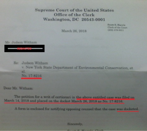
1,300,000,000 Pieces of Admissible Evidence https://www.facebook.com/isacc.witham/videos/701819773318795/ Listen to the United States Supreme Court Discuss the Huge Pile of Toxic Slop …….. https://www.oyez.org/cases/1971/50%20ORIG

SECRETLY FLUSHING VAST AMOUNTS OF SEWAGE AND INDUSTRIAL TOXINS UNDER THE ICE AND SNOW
Warren County and the EMPIRE with the US SUPREME COURT and ARMY CORP OF ENGINEERS and Millions of Others are Witnesses …… Lake Andia’Ta’Roc’Te was engineered / converted to a a MILL POND

Same Crap Different Day
Ticonderoga Branch of Delaware & Hudson Railroad
Ticonderoga (Delano) … The major customer for the railroad on the Ticonderoga Branch was the local paper mill. … Ticonderoga paper mill takes up most of the …
International Paper, others face price-fixing lawsuit …
Sep 10, 2010 · International Paper, … with the average price per short ton increasing to … Thomson Reuters is the world’s largest international multimedia …
History of the American Newspaper Publishers Association
… at the ANPA’s request.2 During the hearings on … 1916, the commission reported, were the International Paper … recommended that newsprint price–fixing be done …
STATEMENT OF BEFORE THE SENATE INTERSTATE AND …
back to 1916) and the published materials, … prices for newsprint until 3 months after l/orld War I … International Paper Co. was recognized as the price leader
-
Judge Refuses to Dismiss Containerboard Products Price …
… class action accusing International Paper … to Dismiss Containerboard Products Price-Fixing Case. … a price–fixing cartel in the mid-1990s …
muse.jhu.edu/chapter/1244402mation concerning price–fixing and selling agreements among the … the commission reported, were the International Paper … port Paper Company, formed in 1916; …
-
International Paper, others face price-fixing lawsuit …
http://www.reuters.com/article/us-paper-lawsuit-idUSTRE68936B20100910Sep 10, 2010 · International Paper, … with the average price per short ton increasing to … Thomson Reuters is the world’s largest international multimedia …
completeclaimsolutions.com/hplclassaction/pds_int_paper/Notice…International Paper Company, … approval hearing will be held on October 19, … engaged in a price–fixing conspiracy and that indirect purchasers were harmed as a …
-
In Re: LINERBOARD ANTITRUST LITIGATION | FindLaw
caselaw.findlaw.com › United States › US 3rd Cir.… Smurfit-Stone Container Corp.; International Paper … these characteristics and conditions indicate that a price–fixing … (8th ed. 1916) …
YUP The POISONING OF THE ADIRONDACKS by the Rich and Famous
FLUSHING THE POOP Using Lake George …… EVERYTHING IS RIGGED


Time to Produce ALL The Records, Photos, Films and Charts
LISTEN TO THE US SUPREME COURT CASE regarding the GIANT SLUDGE / SEWAGE Mess in Lake Champlain ……. NEW CASE RECORDINGS …….. https://www.oyez.org/cases/1971/50%20ORIG
Dedicated to Lake George Warriors and Glens Falls Indians
The BROWN FIELDS which surround Lake George having over TWO CENTURIES of Sewage ( with all of it’s pollutants ) that has soiled the surrounding land of the BASIN. The more than 15,000 septics and the wastewater systems have created a GIANT MESSY DIAPER of saturated soils laden with ALL SORTS OF CRAP. This huge SHITTY MESS continuously is washed into the Lake EVERY TIME IT RAINS.


| info.R5@dec.ny.gov, Records _Access <Records._Access@exec.ny.gov> |
|||
| cc: | asnye@adkmuseum.org, bondh2@union.edu, “dec.sm.Central.Dispatch” <central.dispatch@dec.ny.gov>, contact@dec.ny.gov, fred.dunlap@dec.ny.gov, fwfish4@dec.ny.gov, info@lakegeorgeassociation.org, info@lgpc.state.ny.us |
||
| bcc: | “Miller, Kristy” <millerk@warrencountyny.gov>, lgville@nycap.rr.com, townclerk@townofticonderoga.org, info@lgpc.state.ny.us, public@dec.ny.gov, “dec.sm.Central.Dispatch” <central.dispatch@dec.ny.gov>, pressoffice@dec.ny.gov, contact@dec.ny.gov, asnye@adkmuseum.org, info@lakegeorgeassociation.org, bondh2@union.edu, northroc@union.edu, jpepper@adkmuseum.org, lrice@adkmuseum.org, info.R5@dec.ny.gov, fwfish4@dec.ny.gov, Bill Howland <whowland@lcbp.org>, fred.dunlap@dec.ny.gov, “Voorhees, Jeanne” <voorhees.jeanne@epa.gov>, paula.mario@epa.gov |
Bibliography and Index of Literature on Uranium and Thorium and …
Sullivan County Radioactive Rocks Hudson Valley Wurtzboro, U. S. Highway 209, … Warren County Allanite Occurrences Loon Lake: 712. Loon Lake, RR cut near, V2 mi. S of Loon Lake depot: 711. Radioactive Rocks Adirondack Mountains Bakers Mills, New York Highway 8, … Lake George, U. S. Highway 9, 2.0—3.0 mi.


SEE The ANNUAL FLUSHING OF LAKE GEORGE 


Down The LaChute River the Poop and Pee Goes
SEE HERE FOR SOME TRUE Glens Fall’s Area History
The Last of the Mohicans, Cooper’s Historical Inventions, and his Cave
James Austin Holden
(University of the State of New York)*
Paper presented at the Eighteenth Annual Meeting of the New York State Historical Association, October 3-5, 1916, Cooperstown, New York.
Published in Proceedings of the New York State Historical Association, Vol. XVI (1917), pp. 212-255.
The Magical Fantastic Dancing Surveys of Queensbury and Warren County …… The REAL HISTORY
Documentary History of New York
This map, I am informed by Peter Nelson, head of the manuscripts section of the State Library, was preserved in a damaged condition, but tbe part saved is complete as to the New York section of it. Another copy of the map is to be found in the Congressional Library collection of geographical atlases in that compiled by Sir R. Dudley, 1646-47. See Congressional Library list of 1909, no. [100].
The map which Doctor Holden supposed had supplied Cooper with his name for Lake George, was at the time believed to be one of the oldest maps of the province extant. It was engraved by Lucini, an Italian, and before the fire of 1911 was in the map collection of the New York State Library.19 It shows the “Horicans” at latitude 42 and inland from “the gulf of Plymouth.”20 Doctor O’Callaghan believed this map, though undated, to have been engraved about 1631.21 More modern authorities, however, would place its construction around 1639 or 1635,22 or perhaps even a little later.
There were other old maps of the New England and New Netherland regions which might have been available for Cooper’s use, but even today some of these are scarce and rare, except in reproductions, so that their accessibility in 1826 is extremely doubtful.
Among them was Nicholas J. Visscher’s map of the New Netherlands, published in 1655, which shows the “Horicans” located somewhere near Buzzards bay, not far from latitude 41 in southeastern Massachusetts, the “Moricans” near the mouth of the Fresh river, and the “Horikans” established toward the upper reaches of the Fresh (Versche), now called the Connecticut, river, between latitude 43 and 44. They, with the river, are placed, however, to the westward of Lake Irocosia, or Champlain, on the map instead of the eastward, as they should have been.
Here is an embarrassment of riches, where we have “Horicans” and “Horikans,” to say nothing of “Moricans,” to choose from,23 each one located many miles away from the others.
Next we have Adriaen vander Donck’s map of the New Netherlands, published in 1656,24 which shows a tribe called Horikans on the upper reaches of the Versche (Fresh) river (the Connecticut) about opposite “Fort Orange” (Albany) and “Colonye.”
It seems strange that vander Donck did not describe the various nations named on his map, as he has given us a very good pen picture of the New Netherlands in his “Representation” of 1650, with a description of the “Fresh river.”25
Miss Cooper, in her introduction to the Houghton and Mifflin edition of Cooper of 1896, has tried to show that the Dutch writer, DeLaet, places the tribe of the Horicans near Lake George. I do not read the passage in the same way, nor do I agree with her conclusions.
De Laet says, in his New World, in chapter 8: “Next on the same south coast, succeeds a river named by our countrymen Fresh River [the Connecticut]…at the distance of fifteen leagues…nation is called Sequins. From this place the river stretches ten leagues, mostly in a northerly direction, but is very crooked;…the natives there…are called Nawaas. This place is situated in latitude 41º 48′. The river is not navigable with yachts for more than two leagues farther, as it is very shallow and has a rocky bottom. Within the land dwells another nation of savages who are called Horikans; they descend the river in canoes made of bark.” That is the present Connecticut river, not the Hudson.
Since preparing the foregoing the writer has been fortunate to find26 in the New York State Library a copy of the rare 1630 edition of DeLaet’s “Beschryvinge van west Indien.”27 In this the original passage runs: “Binnen in het landt woondt een ander natie van Wilden welck sy noemen Horikans, die dese rivier af komen met canoen van basten ghemaeckt.” This, A. J. F. van-Laer, New York State Archivist, has translated as follows: “In the interior of the country dwells another tribe of Indians whom they call Horikans, who come down the river in canoes made of bark.” This it will be noted closely corresponds with the rendering given in Jameson, it being kept in mind the river in question is the Connecticut of today.
In this old Elzevir edition are two rather interesting maps of collateral interest, on one of which,28 showing about latitude 45-46, are two unnamed bodies of water similar in shape to Lakes Champlain and George. Beyond these are two other bodies somewhat similarly joined together, one marked “Grand lac,” the other “lac des Yroquois,” On the other map, however, between latitude 43 and 46, are two bodies of water joined together to form “Lac de Champlain” and {“}Yroquoys,”29 which more nearly resemble in location and shape those we are familiar with.
It is plain from an examination of DeLaet’s description, therefore, that by no possibility of translation can the Horikans (with a “k”) be transferred except by force to the Lake George region30 from the Fresh or Connecticut River, down which “they descend in bark canoes.”
After describing the “Fresh” river, DeLaet gives a description of the “Great river” (the Hudson), as far as “Fort Orange” (Albany). He mentions the Mackwaes (Mohawks), the enemies of the Mohicans, but in no way describes the Horicans, as being located in this section, and certainly not in the vicinity of Lake George as Miss Cooper intimates.31 Had they been there, DeLaet would undoubtedly have mentioned them, as they would have been the natural enemies of the Iroquois, or Mohawks.32
The English publisher, John Ogilby, shows the “Horikans” on the upper reaches of the Versche river on his map “Nova Belgii Tabula,” 1670, in his folio atlas of America, but it is evidently copied from the earlier Visscher map, showing the same inaccurate placing of Lake Irocosia to the east of the Connecticut instead of the west and about opposite the latitude of “New Albany” and “Colonye” on the Hudson.33
In Louis Hennepin’s work, “A New Discovery of a Vast Country in America,” in the map at the beginning of the book, is shown what purports to be the region now known as northern New York. The map is neither accurate nor plainly indicated, but near the headwaters of the Hudson and Lake George and Champlain appears the name “Horican.” The query is: Did Cooper refer to this map or some of the others mentioned? Hennepin does not appear ever to have seen Lake Champlain or Lake George, his travels being in the western part of the State, in Ohio, the farther west and the south, and his information touching eastern New York was largely derived from others. His knowledge was second hand, although his map may be good enough for a novelist’s purposes. As a geographer, Hennepin has been rather savagely attacked by historians, and his text assailed as to its accuracy.34
On the subject of the Mahikans, Dr. W. M. Beauchamp has said: “The Mahikans were the most northern nation of the Algonquin family in New York, occupying both banks of the Hudson and for some distance west along its upper waters. Saratoga was once in their territory. They claimed the land for two days’ journey west of Albany and farther south their claim was good. Their southern limits were below the Catskills, and some place them still farther south. South of these were several small nations of this family, whose names and locations are somewhat confused.”35 It will be noted that Doctor Beauchamp, in assigning to the Mahikans an occupation so northerly, nowhere designates them as Horicans.
In considering this matter too, it must be remembered that the original inhabitants of the Lake George region were called “Adirondacks,” or tree-eaters. An old Jesuit Relation says in describing this region: “We find here also the Adirondacks, that is to say, eaters of trees. This name has been given them by the Iroquois in ridicule for their fasting while on the chase (hunting). It has been changed more slowly into that of Algonquins.”36 In neither Father Jogues Narrative nor any of the Jesuit Relations so far as examined does the name of “Horican” appear as a tribe, location or name in the Adirondack wilderness.
John Gilmary Shea has a plausible version of the name. In speaking of Lake George he says: “This is now called Lake George, after one of the worthy monarchs of the name. Some old map had Horicon for Hirocoi, and the misprint has been metamorphosed into a name for the lake….”37
Evidently Francis Parkman agreed somewhat with Shea, for in a footnote he says: “Lake George, according to Jogues, was called by the Mohawks Andiatarocte, or ‘Place where the Lake closes.’ Andiataraque is found on a map of Sanson. Spafford, ‘Gazetteer of New York,’ article ‘Lake George,’ says that it was called Canideri-oit, or ‘Tail of the Lake.’ Father Martin, in his notes on Bressani, prefixes to this name that of ‘Horicon,’ but gives no original authority. I have seen an old Latin map on which the name ‘Horiconi’ is set down as belonging to a neighboring tribe. This seems to be only a misprint for ‘Horicoui,’ that is ‘Irocoui,’ or ‘Iroquois.’ In an old English map, prefixed to the rare tract, A Treatise of New England, the ‘Lake of Hierocoyes’ is laid down. The name ‘Horicon,’ as used by Cooper in his ‘Last of the Mohicans,’ seems to have no sufficient historical foundation. In 1646, the lake, as we shall see, was named ‘Lac St. Sacrement.'”38
The name “Horican” disappears, so far as the writer has been able to discover, from the English maps of the eighteenth century, thereby leading to the supposition that the tribe was either amalgamated or absorbed by neighboring tribes, or had been conquered and made tributary in the numerous petty Indian wars in the latter part of the seventeenth and earlier part of the eighteenth centuries. In his earlier work, “The Indian Tribes of Hudson’s River,” E. M. Ruttenber places the Horicans at the headwaters of the Hudson. He, however, changed his views in regard to the tribe considerably when he prepared his “Indian Geographical Names,” published by this association in 1906.39 at this time he wrote: Horikans was written by DeLaet, in 1625, as the name of an Indian tribe living at the headwaters of the Connecticut. On an ancient map Horicans is written in lat. 41, east of the Narragansetts on the coast of New England. In the same latitude Moricans is written west of the Connecticut, and Horikans on the upper Connecticut in latitude 42. Morhicans is the form on Carte Figurative of 1614-16. and Mahicans by the Dutch on the Hudson. The several forms indicate that the tribe was the Moricans or Mourigans of the French, the Maikans or Mahikans of the Dutch and the Mohegans of the English. It is certain that that tribe held the headwaters of the Connecticut as well as of the Hudson. The novelist, Cooper, gave life to DeLaet’s orthography in his ‘Last of the Mohegans.'”
In fact, in an old map upon which the Queen Ann patent of the Kayaderosseras is based in 1708, what is now Hudson Falls is marked as “3 Falls” and Glens Falls as “4th Falls.”
THE ANCIENT MAPS COME TO LIFE
17. From Cooper’s The Last of the Mohicans, any late edition. Cooper refers here to the “Les Horicans. No map which I have yet seen, or which has been described by others, has this wording of the name. In fact a recent letter from the map division of the Llbrary of Congress says: In answer to the letter…concerning a map, oontaining the name Les Horicans as applied to the Mohlcans, I would say that the name “Horicans” or “Horikans~” oocurs on many early maps but I am unable to find one on which. “Les Horicans” appears…. De Laet’s map gives “Mahicans” with “Les Horikans” in the French edition, 1640. (Memorandum, P. Lee Phillips, chief, division of maps, Library ot Congress, November 6, 1917.) It seems so improbable that Cooper ever saw DeLaet’s Flrench edition, however, I am iforced to believe he made here a slip of memory~ or one of the pen, as he specifies a map in his preface, while DeLaet’s map does not contain the word “Horicans” at all. Again even in the DeLaet text the word is spelled with a “k” which Cooper does not use.
18. Beauchamp.
19. This map, I am informed by Peter Nelson, head of the manuscripts section of the State Library, was preserved in a damaged condition, but tbe part saved is complete as to the New York section of it. Another copy of the map is to be found in the Congressional Library collection of geographical atlases in that compiled by Sir R. Dudley, 1646-47. See Congressional Library list of 1909, no. [100].
20. E. B. O’Callaghan, The Documentary History of the State of New Yark. Albany, 1849, 8vo. ed., 1850, 4to ed., map to face title page.
21. Id. note to 4to edition.
22. P. L. Phillips, chief, division of maps and charts, Library of Congress, List of Geographical Atlases, v. 1, Washington, 1909, p. 214.
23. See map reproduced in colors In E. M. Avery’s History of United States, Cleveland [1905], v. 2, p. 246-47, insert; also id, in John Fiske’s Dutch and Quaker Colonies in America, Houghton, Mifflin and Co., ed. 1903, op· p· 203-4, insert.
24. Reproductions of this map are shown in Collections of New York Historical Society, 2d series. New York, 1841, op. title page; in Justin Winsor’s Narrative and Critical History of America, Boston and New York [1884], v. 4, p. 439; in Proceedings of the New York State Historical Association, v. 6, 1906, op. title page, Indian Geographical Names, by E. M. Ruttenber; and in J. F. Jameson’s Narratives of New Netherland, 1609-1664, Scribners Sons, New York, 1909, op. p. 294. Other reproductions of this map are listed in Winsor, v. 4, P· 438, note 4.
25. Collections of the New York Historical Society, 2d series, New York, 1841, v. 1. p. 125-243. Jameson’s Narratives of New Netherland, p. 295-354.
26. Through the kindness of Peter Nelson in charge of the manuscripts section of the State Library.
27. Leyden, 1630, Elzevirs’ edition.
28. Op. p. 88.
29. See map marked “Nova Francia et Regiones Adiacenti.”
30. Hedges, United States Government ethnologist, is in error in his conclusions that the Horicons were “a people living on the head waters of the Hudson,” nor do his quoted authorities uphold his conclusions. Had he said head waters of the Connecticut, he might have been nearer the fact. Handbook of American Indians, North of Mexico, Washington, 1907, part 1. p. 569.
31. Miss Cooper’s introduction, P· XLIII.
32. See extracts from DeLaet’s New World, in Jameson’s Narratives of New Netherland, 1625, 1630, 1633, 1640-1, p. 43, 47.
33. Wlnsor’s Narrative and Critical History, v. 4, p. 392. Note “from Ogilby’s America p. 169.” A copy of this rare London
Atlas of 1671 is in the State Library at Albany and shows the whole of this map instead of the part of it given in Winsor. From from this it is clearly taken from the earlier Visscher map.
List of Maps and Super Illustrations / Books
Images for Nova Francia et Regiones Adiacenti
Adriaen vander Donck’s map of the New Netherlands
Lucini map of the New Netherlands
DeLaet’s Beschryvinge van west Indien
Doctor Holden states that the lake had four names, namely, An-di-a-ta-roc-te,13 given it by the Iroquois according to Father Jogues, and meaning “the place where the lake contracts,” Can-i-de-ri-oit,14 “the tail of the lake” (Champlain), supposed to be a Mohawk term, Lac du St. Sacrement, “lake of the blessed sacrement,” {sic} given it by Father Jogues in 1646,15 and Lake George, in honor of the reigning monarch, bestowed by Major General William Johnson in 1755, in honor of his king.16
